After the flood
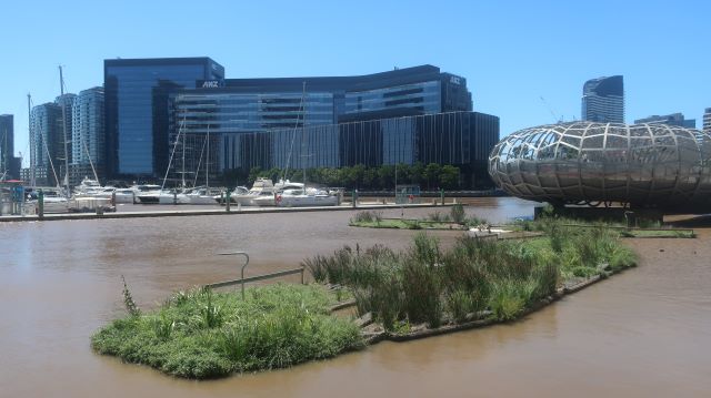
On Friday 14th October, the Maribyrnong River flooded, peaking at 4.18 metres. On Saturday, commercial shipping, including the Westgate Punt, was suspended at the direction of the Melbourne Harbour Master. The Yarra Birrarung at Westgate Park on Friday evening was high and wide and densely laden with material washed off the combined catchments of the Maribyrnong and the Yarra but it did not over flow its banks.
The role that the flood wall at the Flemington Racecourse may have played in exacerbating the flooding and its impacts on residents will be reviewed. The contrast between the protected racecourse and flooded homes led to widespread community anger.
Affected residents said that the flooding had come quickly, and even more quickly, than the warnings advised.
In this climate emergency, we can no longer rely on the past pattern of rain events to predict the future, yet this has been the prevailing model. The flooding was attributed to a range of factors – intensification of residential development further up the catchment accompanied by a great increase in impervious surfaces, a sodden catchment and the very intense rainfall in a short period of time – as well as the particularities of the Maribyrnong River and its floodplains.
We are asked to play our part by taking responsibility through preparing for flooding. This begins with the provision of accurate and timely information.
The State Emergency Service provides helpful local flood guides to South Melbourne, Elwood, St Kilda and Balaclava (I note there is no Port Melbourne guide). The South Melbourne guide includes Montague, now part of Fishermans Bend, which is well known for flooding. The York St Bridge near the South Melbourne Market, while not enjoying the notoriety of the Montague St Bridge, can reliably be expected to feature on the news when a driver enters its floodwaters.
This particular spot in Gladstone Lane in Montague regularly floods when the River backs up and stormwater cannot drain.
The Fishermans Bend renewal area is low lying and includes land that is currently affected by stormwater flooding, riverine flooding from the Yarra River and tidal inundation, as well as being vulnerable to future sea level rise effects. The Fishermans Bend Water Sensitive City Strategy details the range of approaches that will be taken to managing water in Fishermans Bend. These include using stormwater to green landscapes and water trees, rainwater tanks, upgraded drainage, pumps and recycling water.
In the longer term, a levee is suggested on the northern boundary of Fishermans Bend2. The levee that will best serve Fishermans Bend and Melbourne in the future will be a major piece of infrastructure and likely to be informed by international and local experience and knowledge. The role that green infrastructure and nature based solutions can play in flood protection will hopefully inform the planning.
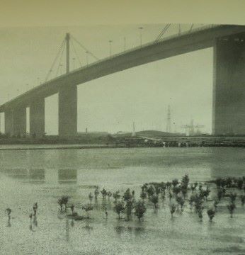
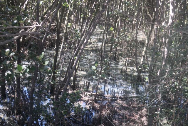
White mangroves were planted in the highly degraded Stony Creek Backwash by far sighted Mark Adams in about 1984.
Over time, the mangroves have thrived and expanded to become dense and abundant and fringed with saltmarsh.
Mangroves, saltmarshes, and seagrasses are collectively known as ‘blue carbon’ ecosystems. Blue carbon ecosystems can store up to 40% more carbon than terrestrial ecosystems.
The mangroves at Stony Creek are now the subject of intense research and investigation by the Blue Carbon Lab at Deakin University.
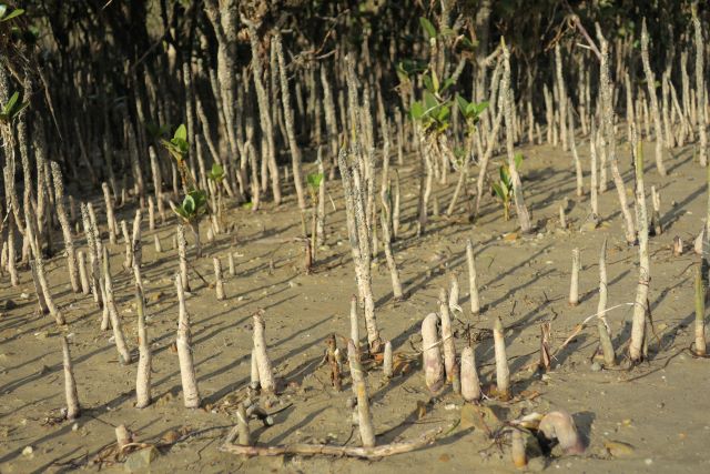
Mangroves have unique adaptations that allow them to survive growing in seawater. Most notable are the numerous breathing roots or pneumatophores that poke up out of the ground surrounding the trees. They also bear live seeds or propagules ready to drop from the tree and take root quickly once settling on the tide and establish themselves as seedlings. They have an intricate network of lateral roots through which sediments settle.
Mangroves grow in an ever changing and very dynamic environment between the tides. Mangroves cope with the volatile physical environment of tidal movement and inundation, waves and coastal winds and high concentrations of salt.3
Mangroves are sometimes called the ultimate giving tree. They provide protection against coastal erosion, nurseries for fish, stormwater cleansing, bird habitat and store carbon.
If the best time to plant a mangrove was in 1985, to adapt the saying, then the second best time is now.
On Saturday, the troubled waters of the Maribyrnong settled among the mangroves at Stony Creek Backwash.
Sources
1 Dennis, Chrisy Landscapes Recycled: Changing Environment of Melbourne’s West
2 p19/44 Fishermans Bend Water Sensitive City Strategy May 2022
3 Harty, Chris Mangroves in Westernport Discussion Paper, February 2011


Leave a Reply