Wetlands
Port Places terrain was originally as much ‘wetscape’ as landscape.
Henry Laird Cox’s 1864 chart conveys this at a glance. Historian Gary Presland, in introducing Cox’s chart, is always at pains to point out that it is not a map, but a hydrographic chart. It shows depth soundings. Nevertheless, the shape of some of the larger wetlands such as Albert Park is familiar, while the Sandridge Lagoon, a recurring presence in Port Places, is also recognisable.
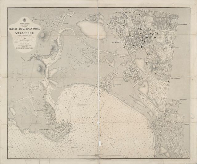
Cox’s chart, while hugely valuable, is deceptive if we fail to heed that it a hydrographic chart, and not a map. It records a moment in time. It can mistakenly be interpreted that those wetlands had a fixed shape, whereas they filled and dried according to the wet and dry seasons.
Rod Giblett’s life of scholarship has been dedicated to wetlands. He points out that ‘their distinctive ecosystems are reduced to outlines on a map, if indeed they are mapped at all . . . A map indicates surface and not depth; it reduces depth to surface, and only at a certain point in time.2
This remains an issue to this day. If a water body is not mapped, it does not exist.
World Wetlands Day is celebrated each year on 2 February. While international days come thick and fast, I explore a wetland each year, and pick up on the theme.
Australia has 67 wetlands recognised as internationally important under the Convention on Wetlands (known as the Ramsar Convention). The western shoreline of Port Phillip Bay is listed under the Ramsar Convention.
The theme of this year’s World Wetlands Day was Wetlands and Traditional Knowledge: Celebrating Cultural Heritage.
World Wetlands Day was celebrated barely a week after that increasingly highly charged day, Australia Day, 26 January.
On 31 January, the Petrichor1 Collaborative hosted an event Hidden Swamps of the Birrarung in the Queen Victoria Gardens. The Gardens hosts Tadao Ando’s M Pavilion which will stay in the Gardens until 2030.
The walk and workshop was to remind us of that this place was once a wetland, and kindle our vision for how it might be transformed in the future.
Queen Victoria Gardens is an island of parkland severed from the Yarra Birrarung by Alexandra Parade.
A feature of the Gardens is the memorial to Queen Victoria, unveiled on Empire Day in 1909. It is elevated on a mound among a bed or roses. It was vandalised in the days preceding Australia Day.
Across Lilinthgow Avenue is the resting place where 38 Aboriginal people from tribes across Victoria were reburied in Kings Domain on 22 November 1985. They were repatriated from the Museum of Victoria where they had been held as research specimens. The site was chosen in the absence of being able to determine their origins.3
This is the site of Camp Sovereignty.
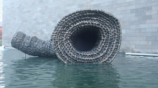
We spent some time with Wurundjeri artist Aunty Kim Wandin’s iuk bagurrk gunga. The bronze and steel sculpture was commissioned by the City of Melbourne in collaboration with the NGV as as a tribute to the history of Wurundjeri women. The artwork celebrates their weaving tradition and the enduring connection with the short-finned eel, referred to as “iuk” in Woiwurrung language. Aunty Kim said her weaving honours her ancestors, her grandmothers and the Aboriginal women that look after family.
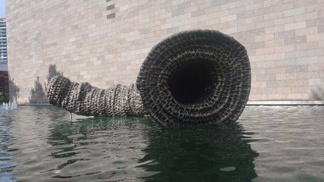
The sculpture sits in the moat, its fluid shape contrasting with the geometric form of Roy Grounds NGV and the solidity of the bluestone. The sculpture represents an eel trap where eels embarking on their journey to the Coral Sea would swim into the trap. Smaller eels could slip through the weave.
Queen Victoria Gardens, unlike other parks after the prolonged hot and dry weather, is lush and green. The grass is soft underfoot.
During the last drought, the City of Melbourne adapted the ornamental ponds in the Gardens as part of an extensive stormwater retention and re-use scheme.
Stormwater from St Kilda Rd flows through a series of pipes and ponds to storages in Alexandra Gardens where the water is re-used for irrigation of the gardens.
1 To find out more about the meaning of petrichor, and how the CSIRO coined the word, click here
2 Rod Giblett Cities and Swamp Settling: decolonizing wetlands Journal of the South Pacific Assoc for Cwlth Lit and Language Studies
Number 36, 1992
3 An historical overview of the desecration of Aboriginal burial places and repatriation of Ancestors back to Country.

Leave a Reply