Wetlands in Port Places
World Wetlands Day is celebrated each year on 2 February to raise awareness about wetlands. This day also marks the anniversary of the adoption of the international Convention on Wetlands in Ramsar, Iran in 1971.
Australia is one of 172 parties to the Convention. There are 67 listed Ramsar wetlands in Australia of which 12 are in Victoria.
There’s new appreciation for wetlands.
Wetlands include swamps, marshes, billabongs, lakes, salt marshes, mudflats, mangroves, coral reefs, fens, peat bogs, or bodies of water – whether natural or artificial, permanent or temporary.1
Wetlands cleanse water as it filters through plants. They provide food and shelter for resident and migratory birds, protect shore lines from erosion, and are rich biodiversity.
Wetlands, and the life they support, are under increasing threat from urban encroachment, port development, pest plants and animals, and climate change.
New appreciation, rather than re-newed appreciation, since historically wetlands have been denigrated, not only in Australia, but all over the world. Hills, mountains, and clear sheets of water were valued for their aesthetic value, grassy plains for their agricultural potential.# Wetlands, by contrast, were seen an barriers to productive uses of any kind, and unhealthy as well.
In our immediate area, large wetlands like the West Melbourne (Batman’s) swamp and the Sandridge Lagoon went from being picturesque lagoons to rubbish dumps.
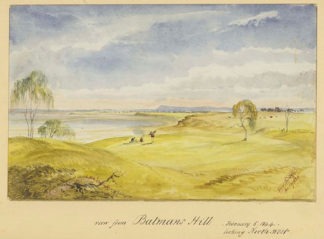
This view of from Batman’s Hill, painted by Robert Russell and dated 5 February 1844, shows the extent of the West Melbourne swamp.
Their malodorous condition led to demands that they be filled. The Sandridge Lagoon was progressively from the northern to the southern end in the late 19th century. The West Melbourne swamp only ‘vanished’ in 1976.
Some wetlands were retained and reshaped for ornamental purposes and recreation such as Albert Park Lake.
The places that I think of as Port Places are those through which the Yarra Birraung flows from Queens Bridge to the River entrance. Tim Flannery, in an attempt to kindle our imagination, described the estuary of the Yarra River as being ‘a kind of temperature Kakadu’.
My imaginative references are the area of saltmarsh removed to extend Webb Dock in 2013, shown below, and the RAMSAR listed wetlands on the western shoreline of Port Phillip Bay.

The low lying lands of Fishermans Bend were unsuitable for residential development at the time of settlement. By the 1930s, they were beckoning as opportunities for expanding industry.
Charles Daley, in The History of South Melbourne, expresses contemporary thinking about the transformative potential of industry.
“The once-despised Fishermen’s Bend—a no-man’s-land—under the pressure of economic circumstances, has come into its own, and its sodden expanse bids fair, under the exercise of human knowledge, skill and labour, directed to its reclamation, to provide eventually scope for great projects and undertakings conducive to the advantage of the State.”2
As part of the re-valuing of wetlands, new wetlands are being created.
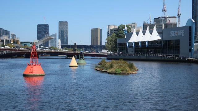
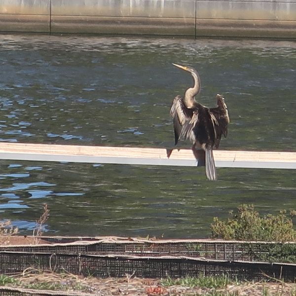
The City of Melbourne installed floating wetlands at three sites in Docklands in December 2022. Since then, the vegetation has grown. Swans have bred successfully at all three sites.
Great care was taken with the siting and design of the wetlands. All the sites are close to the shore so that people can interact with them, but far enough away to be protected from cats and dogs. The salinity varies at each of the three sites, and different birds are found at each one.
Anticipating the needs of animals which the project designers hoped to attract to the wetlands, they incorporate many features: a ramp for the birds to access the wetland, banisters and roosts to mimic the overhanging branches where cormorants like to dry their wings.
These small wetlands carry a heavy burden of expectation in attempting to emulate the range of conditions that the once vast wetlands would have provided.
The vegetation needs to be maintained, like a garden, to ensure some plants don’t take over. The swans need extra nesting material. The design has been modified as the birds’ needs are better understood.
The floating wetlands are being closely monitored by researchers for birds and for nature/human interaction. The findings will help in the design of any new floating wetlands.
One of the floating wetlands is outside Library at the Dock in Victoria Harbour, formerly Victoria Dock.
This map, annotated for a Royal Historical Society of Victoria exhibition, The Swamp Vanishes, shows the former course of the Yarra River and the extent of the West Melbourne swamp. I have further annotated the map to show two of the floating wetland sites. (red circles)

Animals and plants have responded to the floating wetlands. Life and nature has returned to this part of the River. But look how tiny the floating wetlands are in relation to the wetlands that have been lost!
There’s an opportunity to do so much more to bring wetlands and all the life they support into the lower Birrarung.
The concrete edged River at Docklands seems to be calling out for more ‘nature’ interventions. As the late Michael Sorkin exhorted an audience in Melbourne ‘make every surface ecologically active’.
# Acknowledgement: Dr Rod Giblett is a scholar who has created a body of work on wetlands, their intrinsic value and their longstanding neglect in our culture. Every day is a wetlands day for him. His unstinting advocacy for these ‘wetscapes’ has motivated me.
1 taken from Australian Government DEECW About wetlands
2 Charles Daley The History of South Melbourne
More
The Swamp Vanishes – a digital exhibition on the Royal Historical Society of Victoria website.
3 Comments
-
John Milne
Interesting Janet, you should provide a magnified pic of the 2 Red Circled Wetlands area you mark. Very pretty bird, the Rail you show.
-
agree John. I had the same thought.
-

Stephen Pennells
https://photos.app.goo.gl/qFJcv7F3Zjv1tsMUA Morwell Wetlands - Firmins Lane, on way to Treaty Day Out Morwell