
Coode Island
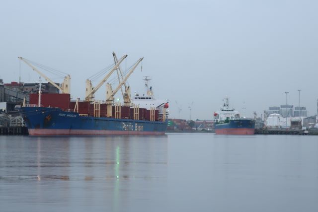
On a golden evening earlier this week, I attended an event at Pier 35 on Lorimer Street, Fishermans Bend. The name Pier 35 marks the last of thirty five wharves along the South bank of the River, starting at Spencer St.
Just downstream of Pier 35 was Rotten Row where old ships decayed. Wandering Port boys would explore these scary exciting places until chased away by watchmen.
The present site of Pier 35 is marked in the photo below.
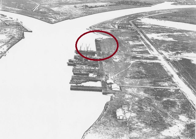
Pier 35 occupies a significant place where the Yarra Birrarung and the Maribyrnong Mirring-gnay-bir-nong Rivers meet. A confluence – a coming or flowing together.
This is the view from the deck of Pier 35 up the Maribyrnong River. Coode Island is to the right of the picture.
Coode Island was created from the implementation of Sir John Coode’s recommendations to the Melbourne Harbor Trust in the late 1880s. The MHT had engaged Coode to seek his advice on how to improve navigability for the ever larger vessels visiting the Port, and how to deal with damaging riverine flooding.
The course of the Birrarung in the early days of colonisation was described as ‘sinuous’. The tight and shallow curve at Fishermans Bend made it difficult for ships to navigate. It added time, distance and expense to the last leg of the journey into Melbourne. That was why many people preferred to disembark in Port Melbourne and make their way overland to the city.
Those floodwaters coming down from the headwaters of the River spread over the low lying lands making them rich and abundant in plant and animal life.
Coode had experience of designing ports and harbours around the Empire. He used plain language in his report:
“The most noteworthy feature with respect to the line, or natural course of the river within its tidal compartment, is the sharp and inconvenient curve known as Fisherman’s Bend; the radius of curvature at this point being only 1,600 feet, it follows that even if the channel were deepened throughout to any practical extent it would not be possible for the longest class of vessels to reach the city, if this curve were retained.”
Instead he recommended “the substitution of a properly proportioned channel upon lines of even curvature for the present sinuous track”.1
Coode’s far-reaching, river altering, recommendation was implemented. A canal was dug between two points along the River.
Until the late 1980s, the new course of the River was still marked ‘Coode’s Canal’ in the Melways and the former City of Port Melbourne boundary followed the former course of the Yarra River.
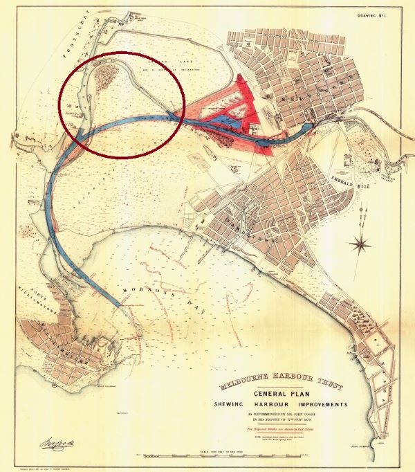
Coode also recommended the creation of Victoria Dock (now Docklands) using the eastern part of the West Melbourne swamp and getting rid of the Falls which for centuries had separated salt from fresh water at today’s Queensbridge.
The old course of the Yarra remained as a shallow channel for many decades, creating an area of about 240 acres surrounded by water. The Island was then effectively isolated from major human impact from the 1880s to 1950s. As such it became a sanctuary for wildlife, ‘a paradise for birds’.2 Coode Island was also used for aviation. Over time the swampy land was increasingly used for the storage of hazardous materials.
That same Wednesday morning, a chemical explosion and fire at the ACB Group chemical factory in Derrimut thrust clouds of toxic black smoke into the air. It appears that the force of the explosion overwhelmed the stormwater protections and toxic run off has made its way into surrounding waterways. Residents were advised to stay indoors and close the windows. Investigations are underway.
Looking across at Coode Island on that calm and golden evening, it was timely to remember of the Coode Island fire on 21 August 1991 when an explosion occurred. A 600,000 litre chemical storage tank filled with acrylonitrile exploded and caught fire. The fire burned various hazardous chemicals including acrylonitrile, phenol, methyl ethyl ketone and benzene forming clouds of potentially toxic black smoke up to 30 km from the site.
Had it not been for a very strong wind, the fire could have been catastrophic for neighbouring residential and worker communities.
A Coode Island review panel, chaired by John Landy, was established. The Panel looked at short term safety measures and reported on the long term storage of bulk liquid hazardous chemicals in Victoria. The Panel found a poor record of the safe management of chemical storages and recommended that the chemical storage facility be moved to Point Wilson.
That move did not eventuate. Instead, stronger controls and procedures were put in place at Coode Island.
Tottenham industrial fire
On 30 August 2018, hydrocarbons, acetone, herbicides and heavy metals entered Stony Creek following the Tottenham industrial fire.
Plants and animals died as result of contaminated firewater runoff. This included about 2,500 fish deaths in the creek and estuary. The creek is now safe again for recreational water use.
The long rehabilitation of the waterways affected by the Derrimut fire – Kaye’s drain, Anderson’s swamp and Cherry Creek now begins.
References
1 Fishermans Bend Heritage Study prepared for Places Victoria 11 June 2013
2 Reports by Sir John Coode, C.E. on Works of Improvement to the Port of Melbourne (1879 and 1886)
3 Phillip Mallis Toxic smoke over Melbourne: the 1991 Coode Island Fire

Heather Wheat
Fascinating - and horrifying remembering those fires. Fridays/Saturday morning have become my time for history lessons. Thanks Janet.